


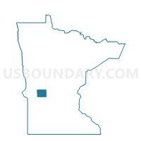
Glenwood P-2, Pope County, Minnesota
About
Outline

Summary
| Unique Area Identifier | 603763 |
| Name | Glenwood P-2 |
| County | Pope County |
| State | Minnesota |
| Area (square miles) | 1.06 |
| Land Area (square miles) | 1.06 |
| Water Area (square miles) | 0.00 |
| % of Land Area | 100.00 |
| % of Water Area | 0.00 |
| Latitude of the Internal Point | 45.66032890 |
| Longtitude of the Internal Point | -95.39723780 |
Maps

Graphs
Select a template below for downloading or customizing gragh for Glenwood P-2, Pope County, Minnesota


Neighbors
Neighoring Voting District (by Name) Neighboring Voting District on the Map
- Glenwood P-1, Pope County, MN
- Glenwood Twp. Voting District, Pope County, MN
- Long Beach Voting District, Pope County, MN
- Minnewaska Twp. Voting District, Pope County, MN
- Reno Twp. Voting District, Pope County, MN
Top 10 Neighboring County Subdivision (by Population) Neighboring County Subdivision on the Map
- Glenwood city, Pope County, MN (2,564)
- Glenwood township, Pope County, MN (1,058)
- Minnewaska township, Pope County, MN (500)
- Reno township, Pope County, MN (397)
- Long Beach city, Pope County, MN (335)